Showing posts with label ice cream. Show all posts

Wednesday, March 16, 2022

Five Points Plaza in the Historic West End

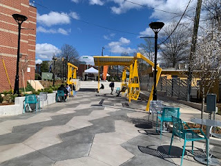
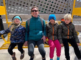
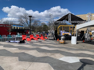
This past weekend, our family took a fun outing to the grand opening of Five Points Plaza, a beautiful new community space located across from Johnson C. Smith University. Situated at the spaghetti-junction intersection of Rozzelles Ferry Rd., Trade St. and Beatties Ford Rd., Five Points Plaza offers formality to what's long been considered the gateway to the Historic West End.  

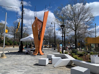
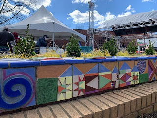
In this thoughtfully designed area, which spans two corners on opposite sides of Rozzelles Ferry Rd., you'll find swings, an amphitheater, a splash pad, public Wi-Fi, tables and chairs, solar lighting, brick pavers, and a decorative wall. 

Another remarkable feature is the artwork, which includes two public pieces, called the Excelsior Collection (after the landmark Excelsior Club), commissioned by the City of Charlotte and created by J Stacy Utley + EVOKE Studio Architecture. One of the installations is called "Ever Upward" and the other is titled "Even Higher." Both names are a nod to Latin definitions of the word "excelsior." 

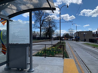
A trip to visit Five Points Plaza can be an adventure in and of itself (let me recommend a ride on the CityLYNX Gold Line -- currently free! -- to get there; there are two train stops -- Bruns Ave. and Johnson C. Smith -- straddling the Plaza). But community-led teams are already planning events and festivals to take place regularly in the newly designed space. Check out upcoming events here

Next time we go back, we'll include a stop at neighboring Rita's Italian Ice and, in the heat of summer, will opt for a dip in the splash pad. 

Another great option while you're in the area is to take a Neighborhood Walking Tour, created by renowned Charlotte historian Tom Hanchett. 

While Five Points, in such close proximity to uptown, has long been a local hub for activity, it's seen a remarkable renaissance in recent years. If it's been a while -- or never -- since you've visited the beautiful, sprawling campus of Johnson C. Smith University, or enjoyed a walk along the neighborhood streets of the Historic West End, consider the opening of Five Points Plaza an excuse and an invitation to check out this beautiful, burgeoning part of Charlotte. 

Note: Five Points plaza is open 6 a.m. to 11 p.m. daily. Public Wi-Fi can be accessed by searching for network name Five Points Plaza.

How to get there: 
Five Points Plaza is located at 1803 W Trade St, Charlotte, N.C., 28216. To get there, I highly recommend you take the train! CityLYNX Gold Line is currently free and offers two stops (Bruns Ave. and Johnson C. Smith) a short walk from on either side of Five Points Plaza. 

Alternately, there are some on-street parking spaces and a few parking decks (Mosaic Village Parking Deck/1601 W. Trade St., Charlotte NC 28216; SP+ Parking/116 S. Cedar St., Charlotte, NC 28202; 
Gateway Village Parking/700 W. Trade St., Charlotte, NC 28202). 

Of course, walking or riding your bike are other fantastic options. 

Friday, November 5, 2021

Little Sugar Creek Greenway/XCLT: 7th Street to 10th Street

Y'all. We are THIS CLOSE to being able to walk or ride a bike along a safe, protected, vehicular-traffic-free greenway from NoDa to Pineville. With the quiet opening of the Little Sugar Creek Greenway 7th Street to 10th Street segment last week, that grand vision became one step closer to a reality. 

This stretch of greenway, located on the east side of Uptown just outside of the interstate loop, fills a key gap in the Cross Charlotte Trail (XCLT) and provides users safe passage across the I-277/Independence Boulevard interchange, connecting two existing portions of the greenway (Cordelia to 12th St. and E. 7th St to Morehead). 

The new passage is also part of the Uptown CycleLink, a 6.5-mile network of protected bikeways that connect greenways into and across Uptown. 

Some fun features of this segment: 
  • A parklet at the end of Jackson Ave. Here, you'll find a bike maintenance station, an art installation, and benches. 
  • Proximity and access to nearby parks (like Alexander Street Park and Independence Park), businesses and amenities (like Two Scoops Creamery!)
  • A beautiful, panoramic view of Uptown from the Central Ave. bridge over I-277.
  • Fully protected bike lanes with physical barriers on the street portions of the trail. Note the distinctive green paint in crosswalks where crossings are necessary. 

Though this new segment of the Little Sugar Creek Greenway is short (about half a mile), its importance is monumental, representing another exciting, meaningful step toward a truly bikeable community. This is good news not just for folks who enjoy trails for recreation, but for the sustainability of Charlotte, especially as it continues to grow for years to come. 

Join me in taking a celebratory walk or spin along one of our newest urban trails as we eagerly anticipate the completion of the Brandywine (Park Road Shopping Center) to Tyvola stretch of the Little Sugar Creek Greenway, currently under construction. NoDa to Pineville, here we come! 

How to get there: 
The north end of this segment of the trail is at the intersection of E. 10th Street and E. 12th Street, near Alexander Street park (where you can find parking). The south end is located at the intersection of Central Ave. and E. 7th St., near Memorial Stadium (1218 Armory Dr., Charlotte, NC, 28204) and the Grady Cole Center. The greenway is well marked with directional signage and road markings. 


Thursday, June 24, 2021

Urban Excursion: Books, Art Walk and Ice Cream

It's summertime! Looking for something to do with the family between camps, vacations and trips to the pool? Consider a visit to Uptown. Here's an outing we did the other day that had a little something for everyone and was fun for all. 

Park at Imaginon (300 E. 7th St.) and visit the library for books, story time, quite indoor play space, a summer scavenger hunt and other activities. During this phase of reopening, parking is free in the Imaginon deck. But even during normal operations, it's only a few dollars for several hours with validation. 

Hop on the Rail Trail and head north to find the first stop on the Uptown Charlotte Mural Tour. This 13-stop virtual walking tour is one of a number of fun tours created by the city of Charlotte and the UNCC Charlotte Urban Institute. We found it to be a fun and engaging way to traverse center city. The tour app makes it easy to navigate from one stop to the next and there's a scavenger hunt element to discovering the artwork -- especially some of the more hidden pieces. The kids, in particular, found this exciting. 

Stop for a picnic lunch at Romare Bearden Park (300 S. Church St.) or The Green (435 S. Tryon St.), then take another short stroll to the newly-opened Golden Cow Creamery (601 S. Tryon St.) for a sweet treat. 

Follow the Rail Trail back to Imaginon and pop across the street and spend some time at First Ward Park (301 E. 7th St.). If you pack a towel for the car ride home, a run through the fountains is a wonderful way to cool down and wrap up your outing. 

All together, we spent a few hours enjoying this urban excursion. Of course, you can do an abbreviated version of this itinerary, or extend it with plenty of other fun things to do in Charlotte's Center City. However you do it, a trip Uptown is an enjoyable summertime outing. 

Thursday, March 18, 2021

Riverbend Farm Trail

Years ago, we discovered Riverbend Farm for it's pumpkin patch and epic playground (Check it out: Our Favorite Pumpkin Patch). At the time, I noticed a Carolina Thread Trail sign by the farm and made a mental note to return to explore. Recently, we did and loved it.

Riverbend Farm Trail is an easy, 0.8-mile (one way) natural surface trail, good for all ages and skill levels, that circles the perimeter of the farm. A short distance from the trailhead is a canoe/kayak put-in.

To get to the trail, follow the gravel road to the right of the farm entrance. This will end at a gravel lot. The trailhead is marked with a sign. From the lot and the through first section of the trail, you'll be able to see farm animals grazing.

The trail, which follows the Rocky River, is quiet, peaceful and full of wildlife. We saw deer and racoon prints, heard frogs chirping and saw a number of birds. The trail ends on the far side of the farm at a large sandy area (insider tip: this is a great place to let kids play a while; pack a sand shovel if you think of it!). This section is downright bucolic.

Bonus, Riverbend Farm is a stone's throw from the Sundae Shop, a most excellent stop after a day on the trail. Everything you could ask for in a super relaxed, pleasant, family-friendly outing. 

Note: There are no restroom facilities at the trail; plan accordingly.

How to get there:
The Riverbend Farm Trail trailhead is near, but not at, Riverbend Farm, located at 12150 McManus Rd, Midland, NC 28107. Take the gravel road to the right of the farm entrance. This will end at a gravel lot. The trailhead is marked with a sign. Here's a map to the trailhead parking lot

Don't forget to pack:
  • Comfortable walking shoes
  • Hats, sunglasses and sunscreen
  • Water and snacks
  • Sand toys

Friday, February 19, 2021

Martha Rivers Park

Dear parents of young kids, here's a recreation destination that's sure to dazzle your little ones.

Martha Rivers Park in Gastonia, about 40 minutes west of uptown, is home to a 1-acre playground castle, complete with turrets, slides, ladders and bridges. It's got places to climb and places to hide. It also has swings and a sand pit for digging. Even the tiniest of visitors have their own designated play area.

The magical playground sits within a 58-acre park that also boasts playing fields and restroom facilities.

There are also about 2.5 miles of paved walking paths. We didn't take riding toys when we visited, but it occurred to me that this would make an excellent place to skate, rip-stick and scooter. (Here's a trail map.

In light of the pandemic, I recommend going on an off day at an off time. When we went on a Wednesday afternoon, there were only a handful of other friends there. (But none of them were wearing masks.)

Martha Rivers Park is open dawn til dusk year-round. 

I noted a Pelican SnoBalls within a short walking distance on the way out. It was closed for the season, but I'm already imagining a warm-weather outing to play at the castle and get a sweet treat. Magical, right?

How to get there:
Martha Rivers Park is located at 1515 Neal Hawkins Rd., Gastonia, NC 28056. The castle playground is at the center of the park, between ball fields. You can't miss it. 

Don't forget to pack:
  • Water and snacks
  • Hats, sunglasses and sunscreen
  • Comfortable shoes
  • Riding toys and helmets

Thursday, June 18, 2020

The Plaza Bike Lane

While bikes have every bit as much a right to city roads as cars do, it doesn't always feel safe to hit the streets on two wheels. Especially with young riders. We've only just gotten comfortable with letting the kids leave the sidewalks, and only under certain conditions, like quiet neighborhoods or protected bike lanes. While there are plenty of side streets, designated bike-only lanes are few and far between. Fortunately, there are groups, like Sustain Charlotte, working to change that.

Recently, thanks to the efforts of neighbors, and a partnership between the Charlotte Department of Transportation, Charlotte Fire, and Solid Waste Services, a new, innovative permanent separated bike lane opened. It runs the length of The Plaza, from Central Ave. to Parkwood Ave., connecting the residential neighborhood with adjacent business corridors.

This 1-mile stretch is a fun option for taking a recreational spin, but, importantly, it's also a very practical connector for commuting to a number of destinations.

At the Central Ave. end of the protected bike lane, you can head west toward uptown, south toward the Elizabeth neighborhood or take designated city bike route No. 8 east toward Evergreen Nature Preserve.

At the Parkwood Ave. end of the bike lane, you can take designated city bike route No. 7 to get to NoDa.

Check out the City of Charlotte designated bike route map for directions and other route ideas.

Of course, there are lots of restaurants and shops around The Plaza and Central Ave. We like to ride to the bike lane, take a lap up The Plaza and back, and stop for something to eat at one of the many establishments nearby. The novelty of riding on a "busy street," holds lots of appeal for the kids and everyone enjoys a treat afterwards.

I hope organizations pushing to make bike riding safer and more accessible around Charlotte will keep up the good work. The Plaza separated lane is an asset and a model that should be replicated.

How to get there:
The bike lane segment of The Plaza runs from Central Ave. to Parkwood Ave. If it's not feasible for you to ride to this stretch, you can park on neighboring side streets. Another option is the on-street spaces along Commonwealth Ave., a block south of the Central Ave./The Plaza intersection. Be careful about parking at local businesses; they will tow.

Don't forget to pack:
  • Helmets: Never ride without one.
  • Lights or reflective gear: If it's getting anywhere near dark.
  • Water: Bring plenty for your ride and to rehydrate afterwards.
  • Sunglasses and sunscreen: This route is only partially shaded.

Thursday, March 7, 2019

7 Reasons to Visit Independence Park

Here's a bit of trivia for you: Independence Park, situated in the Elizabeth neighborhood on the southeast edge of uptown, is the city's oldest public park. According to the Charlotte-Mecklenburg Historic Landmarks Commission, it was established in 1904 by Daniel Augutus Tompkins, founder of the Charlotte Observer, who argued that public parks are "a prudent and wise investment because they improve the moral and economic climates in cities." I have to agree.

The 19-acre Independence Park stretches from Charlottetowne Ave. down to Clement Ave. and is bisected by Hawthorne Ave. in between. It's one of our favorite "pocket parks." Here's why:

1. The rose garden: At the lower end of Independence Park (where Park Dr. meets Greenway Ave.), is a beautiful newly renovated garden that features a vintage stone seat wall, mixed plants and shrubs, a crushed stone path and rose beds. We like to get ice cream from the freezer chest at the Dollar General around the block (1949 E. Seventh St.) and enjoy a "dessert picnic" here.

2. Paved trails: The park is just over a half mile from one end to the other. The paved footpaths are perfect for bikes, skates, scooters and strollers. Kids can run free in this relatively enclosed area. The one challenge for anything with wheels is crossing from the upper section of the park to the lower section at Hawthorne Ave. There are ramps, but you'll have to take a more roundabout route than if you walk up the stairs and cross at the crosswalk.

3. Picnic areas: Whether you spread a blanket on the grass or grab a picnic table at one of the half-dozen covered gazebos, there are plenty of pleasant places to eat. We like to get a take-out pizza from Hawthorne's Pizza (1701 E. Seventh St.) just across the street from the park and enjoy dinner al fresco. One of our favorite spots is by the reflecting pool at the edge of the park that borders Hawthorne Ave. Built in 1931, this beautiful stone feature is a memorial to 21-year-old camp counselor Lillian Arhelger, who fell to her death in an attempt to save a Charlotte Girl Scout from falling over the Glen Burnie Falls in Blowing Rock, NC.

4. StoryWalk: Stroll and read. I just love this concept. Here's everything you need to know about StoryWalk. The latest book on display is "The Ugly Vegetables," by Grace Lin.

5. Amenities: In addition to the walking trails, there's a fantastic playground for little ones as well as a baseball field (with batting cage), basketball courts, tennis courts, a volleyball court, and table tennis.

6. Demonstration garden: Located behind the 1940s-era cinder block Armory building beside the tennis courts, these raised-bed and in-ground gardens are maintained by Master Gardener volunteers to teach gardening skills to folks in the community. Herbs and vegetables grown here are given to Urban Ministry Center's Soup Kitchen.

7. Skyline panorama: One of my favorite cityscapes in town. Memorial Stadium serves as the northern-most border of the park, which means no towering developments can obstruct the view.
On a pretty day, any of the above is reason enough to visit Independence Park, and I hope you will. Plan ahead, though. For all its features, it does lack one major convenience: Restrooms.


How to get there:
Parking is available at 300 Hawthorne Ave., adjacent to Elizabeth Traditional Elementary School. There's also a small lot at the lower end of the park off of Park. Dr. between Lamar Ave. and Clement Ave. Here's a park map.


What to bring:
  • Comfortable shoes: Might as well stroll the grounds from rose garden to baseball field.
  • Riding toys: Paved paths are great for bikes, skates, scooters and strollers.
  • Water: There are no restroom facilities to refill.
  • Snacks: Or a bit of money to grab food from a nearby restaurant -- and there are plenty to choose from.

Thursday, January 10, 2019

Art Walk on the Rail Trail

A couple weeks ago, I read an article in the Charlotte Observer about a new art installation along the Charlotte Rail Trail in Historic South End.


Aptly named “The Color Forest,” the sculpture comprises 100 towering poles painted bright colors that line both sides of the track near Bland Street. The work is a collaboration between local artist Ivan Toth DepeƱa and Glen Nocik, who fabricated and installed the display.


One recent sunny day, we hit the Rail Trail to check it out. And I recommend you do the same.


“The Color Forest” is just one of dozens of bright, quirky and curious displays scattered along the trail. Many of them, including an 8-foot chicken, a giant yellow swing set, magic carpet sidewalk murals, an interactive chalkboard and an enormous seesaw, were organized by architect David Furman of Centro CityWorks, a visionary for the Rail Trail itself.


Within a mile stretch of the Rail Trail, you can spot these and a bunch of other noteworthy pieces, including several yellow steel Adirondack chairs, a bright red oversized exclamation point, a wire dinosaur, metal roosters, a parking-deck-sized comic strip, a permanent ping pong table, eclectic benches (with solar charging stations!) and a number of splashy wall murals. Even the rainbow-colored patio table umbrellas at Pike’s Soda Shop and the adornments on the deck at Hot Taco (including the painted cow statue) contribute to the artsy, funky urban South End vibe.


Here’s a good two-mile (out and back) option for a walk, stroll or bike ride to get fresh air, take in fun local art, and discover new things about the Queen City.


Start at the Carson St. station just outside of Uptown. Carson St. intersects South Blvd. at the Dowd YMCA. You can park on the nearby neighborhood streets for free or at Pritchard Memorial Baptist Church for $5 (the church lot serves as a city-sanctioned public lot during business hours. You’ll see an automated pay station when you park.)


From the Pritchard side of the street, cross South Blvd. and take a left on the Rail Trail. It’s exactly one mile to Sycamore Brewing Company, a good stopping/turnaround point with lot to see in between.

Note: There are no public restrooms on the Rail Trail, so consider making a quick stop at the Dowd Y. You don’t have to be a member to visit the guest facilities in the lobby.

The first attraction you’ll come to at Carson St. is the giant yellow porch swings at Edna’s Porch.


In addition to art, along the Rail Trail, you’ll find a bike pump station and plenty of dog-friendly amenities (read: pick-up stations and trashcans).

There are a variety of restaurants flanking the trail, including the American Pub, Blaze Pizza, Clean Juice, Hot Taco, Price's Chicken Coop and Luna’s Living Kitchen. We like Pike’s Soda Shop, a classic Queen City establishment.

In addition to all the things to see along the way, what makes the Rail Trail exciting to me is its proximity to Uptown (those skyline views!), its accessibility (easy to get to and a relatively traffic-free and protected space to walk and ride), and the sense of adventure it provides. It’s a fun, family-friendly place to get out, move around and explore.

How to get there:
The Carson St. station is located at 218 E. Carson Blvd., Charlotte, NC 28203. Park on the street nearby or at Pritchard Memorial Baptist Church across South Blvd. from the station. Follow the Charlotte Rail Trail south, away from uptown.

Don’t forget to take:
  • Bikes, scooters and helmets or comfy walking shoes: The Rail Trail is super pedestrian-friendly.
  • Water: Stay hydrated.
  • Money: For refreshments along the way.
  • Hats, sunglasses and sunscreen: There is very little shade along the trail.